| Overall view
The Jebel (Jabal, Djebel) Uweinat is a mountain range
in the area of the Egyptian-Libyan-Sudanese border, far away from any civilization.
The Jebel Uweinat was first reported by the Egyptian discoverer Ahmed Pasha
Hassanein, who in 1923 passed the Uweinat mountain range.
The mountain is composed of two very different parts. The western part of
the massive consists of a collapsed dome of intrusive granite, arranged in
a ring shape of some 25 km diameter, separated by three eroded wadis, named
Karkur Idriss, Karkur Hamid and Karkur Ibrahim.
The eastern part consists of a large block of paleozoic
sandstone, resting upon metamorphic Proterozoic basement rocks, propped against
the granite dome to the west.
The sandstone slab forms a large elevated plateau
which is topped by four separate units of uplifted sandstone blocks: The split
Hassanein plateau, connected by a narrow neck on which is a volcanic structure
("White Spot"), the Italia plateau and an unnamed plateau in the northern
direction. The highest point of Uweinat is on top of the Italia plateau (about
1,300 m on ground). The cliffs form a perpendicular wall all around of at
least 200 m height.
The high plateaus via four named wadis are accessible:
Karkur Talh from the east and Karkur Murr, Wadi Wahesh from the south.
A southern third valley, Wadi Waddan, crosses the
contact zone between the granite dome and tectonically tilted sandstones at
the edge of the eastern plateau. Here are large parts of the Proterozoic basement
exposed.
|
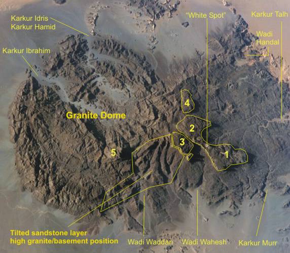
1-- Hassanein P. SE; 2-- Hassanein P. NW;
3--Italia P.; 4--northern unnamed P.; 5--Mt.Bangnold
|
|
A. Structural-geological model of Jebel Uweinat
The Jebel Uweinat is one of several striking sandstone
plateaus in the western desert. They crown the several thousand meters uplifted
Proterozoic basement at the eastern edge of the Kufra Basin (Howar-Uweinat
Uplift). The plateaus consist of remnants of Paleozoic sediments that originally
the entire area has filled, but today is greatly reduced by erosion. Two of
some structures, Jebel Uweinat and Jabal Arkenu, are in the "slipstream" of
granitic ring-intrusions (before 42-46 Ma years in the early Oligocene age)
has been preserved from the total erosion.
The age of the Paleozoic sediments is difficult
to determine because fossils are rare. Trace fossils (Skolithos, Cruziana,
Arthrophycus etc.) indicate Ordovician. The occurrence of Silurian and Devonian
deposits is dominant. But Silurian marine sediments with graptolites (as at
the margin of the Kufra basin) are missing. In contrast, some fossil plant
imprints indicate the Carboniferous age of the uppermost paleozoic layers.
Between the old Paleozoic strata and Carboniferous
deposits there are probably a significant time gap. In the northern Gilf Kebir
(Wadi Abdel Malik) Carboniferous layers at the same level with probably Devonian
strata are encountered. Therefore, we must assume that the Carboniferous strata
were deposited on an already eroded and rugged relief of older Paleozoic layers.
So were Devonian strata in areas between the plateaus of Uweinat, Gilf Kebir
etc mostly or completely eroded. The Carboniferous strata in the Uweinat are
terrestrial-fluvial of origin, and were deposited in paleo-valleys; or they
are of shallow marine origin in the eastern foothills of the Uweinat.
The Uweinat structure is designed by one of these granitic ring-intrusion
and can be divided into four areas today. In the western part (granite dome)
are only remnants of the basement and changed sandstones between the dominant
granites.
In a transition zone between the granite dome (Mt. Bangnold) and the sandstone
slab (Italia plateau), parts of the basement and the entire package of sediments
were uplifted by intrusion of granite and tilted to the north.
The eastward subsequent extensive sandstone slab
was deposited on an uneven relief of the basement. This is documented by outcrops
of the basement in the Wadi Wahesh (+820 m above sea level), Karkur Murr (+750
m above sea level), and in the lower branch of Karkur Talh (+710 m above sea
level).
A special feature are four plateaus, which are
marked by high cliffs. This plateaus crown the sandstone slab and tower over
this partly 200 m. With a maximum height of about +1.900 m SL (Italia plateau)
is simulated a total thickness of the sandstone series up to 1,200 m in the
Jebel Uweinat.
But the four plateaus are significantly uplifted above the level of the sandstone
slab by lateral granite intrusion at the edge of the collapsed granite dome.
Such lateral intrusions under the sandstone slab are documented by some penetrations
of granite on the slab. The Italia plateau achieved the highest uplift rate
and is separated from the other plateaus by a fault (Wadi Wahesh incision).
The original thickness of all paleozoic strata
is unknown, because we have below the four plateaus an eroded relief. But,
in the comparable Gilf Kebir thicknesses of the layers of about 400 m can
be measured. So the entire Paleozoic serie could originally have reached a
thickness of maximal 500 m and is partly reduced to less than 50 m. How this
discrepancy between the apparent thickness of the sandstone series of 1,200
m and the presumed thickness of 500 m can be dissolved, is explained model-like
in the profiles (below).
Structural-geological
models
|
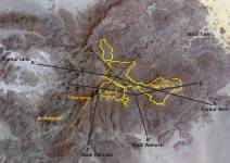
Profiles lines
|
|

Profile A-A'
|

Profile B-B'
|

Profile C-C'
|

Profile D-D'
|
|
|

The mountain ridge of the Hassanein plateau
is built by a tertiary magmatic intrusion and a followed uplift of basement
as well as the sedimentary block. On top of the mountain ridge is placed
a striking crater like structure with a basaltic bottom.
As if to confirm this, in 2007 Mahmoud Marai have found crystals
on top the Hassanein plateau. He sent me a photo and I have identified
the crystals as quartz crystals (see below). That means, in the underground
of the Hassanein Plateau is an uplifted granite ! Into the sandstone
plateau is at least one fissure with connection to the granite.
Then wrote Andras Zboray: The crystals are definitely quartz. We
have found several quartz crystalls on top of the plateau, including some
perfectly formed and transparent. On our ascent we have found a fissure
with crystals covering both sides of the fissure.
|
Uplifted
high plateaus
Tilted sandstone layer
area (Wadi Waddan)
|

|

|

|

|

|

|

|

|
|
Wadi Waddan
|
View from Italia plateau
(3)
|
View from Mt.Bangnold
|
View from the Dome site
|
Tilted sandstone
|
Sandstone-Basement mix
|
Eroded sandstone slab
(with Wadis)
|
|
B. Sedimentary accumulation and stratigraphy
1. Proterozoic basement
rocks
The area located between Jebel Uweinat
and Jebel Kamil is the best area of basement outcrop of the "East Sahara Ghost
Craton". The major rock assemblages were subdivided by Klerkx (1980) and Richter
(1986) into three units namely, the Granoblastite Formation, the Anatexite
Formation and the Metasedimentary Formation.
The Granoblastite Formation (Karkur Murr Form.) consists mainly of
a group of pyroxene ganulites containing charnockitic, noritic, and diopsidic
gneisses and metaquartzites.
The Anatexite Formation (Ain Dua Form.) is dominated by migmatites
interpreted as anatectic granulites and contains abundant supracrustal intercalations.
The Metasedimentary Formation is a low to medium grade supracrustal sequences
with intercalations of bimodal basaltic-rhyolitic rocks believed to be the
source of the layered iron quartzite. The tectonic environment of these rocks
is interpreted as an intracontinental rift (Richter 1986).
Typus locality Jebel Kamil (M. Elkady, 2003)
|

|

|

|

|

|
 |
 |
 |
|
Ultramafic and calc-silicate
rocks
|
Anatexite rocks
|
BIF: Quartz Bands
|
BIF: Metapelite Bands
|
BIF: Iron-Silica Bands |
BIF: Meta-Cherts
|
BIF: Quartz Bands
?
|
High grade granulitic Granoblastite
Formation (Ultramafic-Mafic rocks)
The ultramafic-mafic and calc-silicate rocks (UM) are exposed as spots
or bands in some localities, especially in the southern area. The rocks are
grey to green, fine to medium-grained. The bands consist mainly of high deformed,
fine-grained gabbro-norite. To the southwest of the area, the exposures of
the UM are represented by bands and spots of highly deformed gabbroic rocks,
serpentinite and talc-carbonate.
The presence of olivine and spinel in these ultramafic-mafic rocks indicate
that their parent rock was formed at a relatively high temperature and high
pressure, and originated in the upper mantle.
Remobilized Anatexite Formation
The characteristic feature of the Anatexite sequence is the predominance
of migmatic gneiss, i.e. diatexites, metatexites and metablastites.
Whereas the highly mobilized, medium-grained diatexites are of a homogeneous
to nebulitic texture, rarely showing foliation, metatexites and metablastites
are well-foliated and a two-phase nature - melanosome and leucosome - becomes
obvious, arranged in the form of layers or schlieren and patches.
In the area the Anatexite sequence is usually found in the valleys as isolated
exposures of low relief, consisting of leucosome and melanosome bands. The
leucosome bands with felsic components are buff grey to white, medium to coarse
grained, and composed mainly of quartz and alkali-feldspar. The melanosome
bands of mafic components are greyish green to dark green, fine to medium-grained,
and are composed mainly of amphibole and plagioclase.
Metasedimentary Formation (Banded Iron Formation)
The Banded Iron Formation (BIF) is built up of accumulated clastics of
psammitic and subordinate pelitic character. The BIF bands are well-foliated
and generally fine-grained. The lower part of the BIF exhibits a frequently
cataclastic metamorphism, but some parts still show weak graded bedding. The
BIF succession consists of variegated bands with colours of yellow, red, brown,
black and grey. The iron-rich bands are composed of black magnetite and dark
greyish brown and red hematite alternating with quartz bands, whereas the
silica-rich bands consist mainly of quartz or chert and jaspilite.
Generally, the chert bands dominate in the upper parts of the BIF while the
quartz bands (metamorphosed chert bands) increase toward the base. Chert and
jaspilite bands occupy the top of the formation. The chert contains more hematite
and shows remnants of thin layering in contrast to the quartz rich bands in
the middle and lower part of the BIF succession.
The BIF differs from base to top as follows:
Metapelitic and volcanosedimentary bands; Fuchsite bearing quartz bands;
Well banded iron-silica bands; Lower part of the iron-silica-rich bands.
Eroded
sandstone slab (with wadis)
|

|

|

|

|

|

|

|

|
|
Basement outcrops
|
Anatexite: Mouth of
Karkur Talh (loc 1)
|
Granulite gneiss ?:
SW-branch of Karkur Talh (loc 2)
|
Southern edge and dome
area
|

|

|

|

|

|

|
 |
|
|
South-Uweinat from space |
Wadi Wahesh |
Wadi Wahesh foreland |
Mouth of Wadi Wahesh |
BIF (Quartzbands) Karkur Idris |
BIF, dome site |
|
2. Lower Paleozoic sedimentation
The sediments
of the Paleozoic period rest directly on the uplifted Proterozoic basement.
In between is a significant time gap, because the sedimentation begins
earliest in the Ordovician period. The detection of trace fossils
(Skolithos, Arthrophycus, Cruziana, etc.) is an indication of this.
Cambrian sediments are missing definitely.
The Ordovician and Silurian strata were described first from
the southwestern Gilf Kebir (Abdel-Malik Plateau) by KLITZSCH & WYCISK
(1987). Near the Um Ras Passage approximately 100 meters of fluvial,
deltaic and nearshore marine sandstone occur, interbedded by rare silt-
to fine sand layers, that locally containing abundant burrows of
Cruziana/Arthrophycus as well as Harlania and other ichnofossils
and beds full of Skolithos. |
These sediments are, apart from a marine
sequence, are similar to the of BELLINI & MASSA almost simultaneously
studied deposits in Jabal Rukn and Jabal Asba. These are an extension
the Gilf Kebir towards Libya.
It is believed that the boundary
between the Ordovician and Silurian strata is above beds with rich Skolithos
therein.
In the area of Gilf Kebir and Jebel Uweinat the Ordovician series
is called Karkur Talh Formation (in sense KLITZSCH); the Silurian
series is called Um-Ras Formation (in sense KLITZSCH).
In analogy to comparable stratigraphic profiles in the Gilf Kebir and
Jebel Asba a similar stratigraphic sequence of Ordovician, Silurian
and Devonian is also in the Jebel Uweinat available. The thicknesses
of the layer sequence are confirmed: 25-30m Ordovician (Karkur-Talh
Fm.); 75-80m Silurian (Um-Ras Fm.); about 300-400m Devonian (Tadrat
Fm.).
The Karkur Talh Formation of Ordovician age rest on Precambrian metamorphics,
whereas at other locations the Um-Ras Formation rest directly on the
Precambrian metamorphics and the Ordovician layers were missing.
The same type of strata, also containing Cruziana/Arthrophycus,
Harlania and Skolithos beds, is present in the Egyptian
part of Jebel Uweinat at Karkur Talh.
Three horizons with trace fossil have been identified: In the southern
and western branch of Karkur Talh at about +715 m SL and +740 m SL,
and more recently on the eastern plateau at the higher stratigraphic
position (+805 m SL). Some beds with small thickness at the base of
this serie contains abundant Skolithos sp.
The upper limit of the Silurian strata in the Uweinat is confirmed by
the discovery of the upper Arthrophycus layer, about 100 m above the
basement. Carboniferous strata in the Jebel Uweinat and the wider area
partly overlap directly Silurian strata or the basement. This means
there is a time gap between Carboniferous and Devonian. In this time
the Devonian strata by fluvial erosion were mostly or completely reduced
across the region. The current high plateaus such as Jebel Uweinat,
Gilf Kebir, Jabal Arkenu etc. contain more complete Devonian strata.
The following Devonian strata
(Tadrat Formation) are eroded at the edges of Jebel Uweinat usually
up to the level of the Silurian and Ordovician strata. Its original
thickness is only in the uplifted plateaus preserved.
Carboniferous strata in the Jebel
Uweinat and the wider area partly overlap directly Silurian strata or
the basement. This means there is a time gap between Carboniferous and
Devonian. In this time the Devonian strata by fluvial erosion were mostly
or completely reduced across the region. The current high plateaus such
as Jebel Uweinat, Gilf Kebir, Jabal Arkenu etc. contain more complete
Devonian strata. |
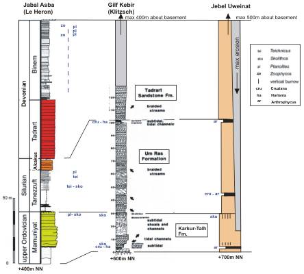
Stratigraphical typus profiles
|
|
The Karkur-Talh Formation is represented
by 25 to 30 meters of well bedded shallow marine sandstone are intercalated
with coarse to conglomeratic fluviatile sandstone.
"The Formation can be interpreted as deposits of subtidal shoals and
tidal channels. The coarsening-upward sequence at the lowermost part
of the section is made up of interbedded laminated siltstone and fine-grained
sandstone with wavy lamination and ripple cross-lamination. It contains
trace fossils. The upper part of this coarsening-upward sequence is
made up of fine- to medium-grained destratified sandstone, containing
abundant Skolithos-burrows. This skolithos-sandstone of up to
two meters in thickness is erosively overlain by tidal channel-sandstone,
consisting of medium- to coarse-grained, trough and planar cross-bedding
with intraformational conglomerates at the channel floor.
The uppermost part of this first shallow marine unit is formed by skolithos-baering,
medium- to coarse-grained sandstone which is poorly defined cross-bedded
and partly conglomeratic. This unit can be up to 18m thick. The density
of the skolithos-burrows increases towards the top. The environment
of origin is assumed to have been subtidal shoals, produced during more
rapid sedimentation.
The second minor shallow marine intercalation in the upper part of the
formation is only up to 5m thick. It is composed of a fining-upward
tidal-channel sequence with trough cross-bedde sandstone and fine-grained
sandstone to shaly siltstones, with partly intensive bioturbation
towards the top. Locally, a subfacies of well-sorted, fine-grained sandstone
exhibiting horizontal and low-angle cross-stratification with parting
lineation occurs. This subfacies indicates upper-flow conditions within
the nearshore environment. The shallow marine intercalations can be
traced to the area of Aqaba passage (Gilf Kebir)."
The Um Ras Formation is typical for
the interface of fluvial and shallow marine environment near the edge
of the Silurian marine transgression (Kufra basin). It has a thickness
of approximately 75-80 meters.
"The deposits of the Um-Ras Formation are descrided as non-cyclic,
braided fluvial systems. This sheet-like, medium- to coarse-grained
sandstone is moderatly sorted and exhibits small- to large-scale tabular
cross-stratification. Grouped sets of omikron crross-stratification
alternate with a minor facies of horizontal stratification, and low-angle
cross-bedding and single pebbly layers. Deformed cross-bedding is frequent
and may occur in successively superimposed sts. The style of deformation
ranges from buckled to overturned and convolute foresets. Braided fluvial
systems are subject to rapid fluctuations in flow velocity and cause
the sediment to be deposited mainly in the form of channel bars. The
planar stacked cross-bedded sandstone is attributed to high-stage deposition
within transverse bars by straight-crested megaripples. The facies association
corresponds to rivers of low sinuosity with linguoid and partly transverse
bars. The abundant overturned foresets within this facies are attributed
to the action of current drag on a liquefied sand bed. The coarse friable
nature of the sandstone make internal fabric conditions an unlikely
cause of liquefaction. An external mechanism such as of tectonism
must be sought."
The Devonian strata of the Tadrat Formation
have not been dated until now by fossils. Lithofacies and stratigraphic
comparisons with the corresponding sequences in th Kufra basin suggest
a straigraphic connection between the fluviatile deposits in the area
of Jebel Uweinat und Gilf Kebir. It has a thickness of approximately
300-400 meters.
"The fluvial sandstone is medium- to coarse-grained, subangular to subrounded,
and moderately sorted. Small-scale to large stacked tabular cross-bedding
is the most common bedding type. Minor lithofacies are the horizontal
bedding, through cross-bedding and the thin-bedded pebble-bearing sandstone
layers. The predominantly non-cyclic fluvial sequences can be interpreted
as braided river deposits. Unlike the Silurian strata, these contain
an increasingly high pebble content. The pebbly sandstone can be seen
as deposits fromproximal outwash braidplains, including some shallow
channels. The paleocurrent direction indicates a NW to locally NE drainage
pattern." Source: KLITZSCH & WYCISK (1987)
|
2.1 Karkur Talh Formation (Ordovician)
Fine stratified to conglomeratic
compact sandstone
|

|

|

|

|

|

|
|
|
|
Southern Uweinat: layer with Skolithos |
Southern branch of Karkur Talh |
|
|
Silty layer with trace fossils
|

|

|

|

|
|
|
|
|
|
Southern branch of
Karkur Talh (+715 m SL)
|
|
|
|
|
|
|
2.2 Um-Ras Formation (Silurian)
Fine stratified compact sandstone
 |
 |
 |
 |

|

|

|

|
|
Boundary between Basement
and Silurian (Karkur Talh; +710 m SL)
|
|
|
|
|
|
Clearly stratified and partly cross-bedded layer
Silty layer with trace fossils
|

|

|
|

|

|
|

|

|
|
Western branch of Karkur
Talh (+740 m SL)
|
|
Southern branch of
Karkur Talh (+740 m SL)
|
|
Eastern Plateau
(+805 m SL)
|
2.3 Tardrat Formation (Devonian)
Uplifted
plateaus
Below of high plateaus (Slab)
3. Carboniferous sedimentation
The presence
of Carboniferous strata has been known for a long time from Karkur Murr
and Karkur Talh at the eastern side of Jebel Uweinat. It was already known,
that the so-named Karkur Murr Formation consist of sandy shales and include
often numerous plant imprints.
But the type locality of Carboniferous sediments is the region of Wadi
Talh (meant is not Karkur Talh) in the Gilf Kebir (Abdel-Malik Plateau)
and is described in detail by KLITZSCH & WYCISK (1987) as Wadi Malik
Formation.
"The lowermost part consists of medium- to
coarse-grained sandstone with grouped sets of small- to large-scale planar
cross-bedding alternating with horizontally bedded medium-grained sandstone.
The percentage of horizontally stratified sets increases towards the top.
Overturned cross-bedding is less frequent in this facies. The facies
type displays conditions of extensive deposits of braided river.
The second part of the succession shows a fining-upward sequence
with a slighlty erosive base made up of medium- to fine-grained sandstone
and intercalated thin laminated shaly siltstone. This cross-bedde pointbar
sequence is 8 to 12m in thickness and is topped by fine-grained, partly
even laminated overbank deposits, which lacally display pedogenetic features.
These facies represents deposits of high sinuosity rivers.
The third part consists of fine-grained sandstone with shaly siltstone
intercalations and horizontal strata. Main bedding types are ripple cross-lamination,
even and wavy lamination and flaser-bedding. Parting lineation can
be observed in the uppermost part of this unit. Ferruginous siltstone
layers and reworked shale intraclasts within scour-and-fill structures
occur. Asymetrical oscillation ripples are common on the bedding planes.
Tadpool nest ripples indicate shallow water conditions in a predominantly
low energy wave-generated environment. This facies can thus be considered
as a marine influenced sedimentary environment in a transition zone from
alluvial to coastal plains.
The uppermost part represents a shallow marine sequence of Late
Visean age. The sequence is made up of various increasingly thick
layers of tidal channel-filled sandstone with distinct erosive contact
which interfinger with the above mentioned facies. Channel-sandstones
with a maximum thickness of up to 3 meters are overlain by thin-bedded
fine-grained sandstone with interbedded clay-iron-stone layers. Intensive
bioturbation, trace fossils such as Bifungites and remains of brachiopods
confirm the marine origin of this probably tidal channel to subtidal
paleoenvironment." Source: KLITZSCH & WYCISK (1987)
Today, more and more solidified the impression
that Carboniferous sediments with abundant plant imprints (Lepidodendron,
Sigillaria etc.), suspected more than before, are the youngest Paleozoic
deposits in the Jebel Uweinat and surrounding (see right).
The Carboniferous strata of surrounding areas are a near-shore facies
of a transgression from the western Kufra basin. The strata overlain unconformably
the southern foothills of the current mountain range the Jebel Uweinat.
Remains of strata from the Carboniferous transgression also were found
extensive in the Wadi Talh area of Gilf Kebir, at the Clayton Craters
in the northern direction of Uweinat and approximately 100 kilometers
southeast of Jebel Kissu.
|
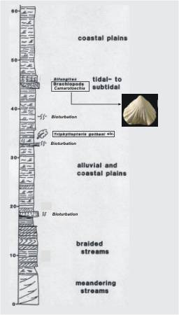
Gilf Kebir: Stratigraphical typus in sense
KLITZSCH & WYCISK, 1987
|
Carboniferous strata in
the Jebel Uweinat and the wider area partly overlap directly Silurian
strata or the basement. This means there is a time gap between Carboniferous
and Devonian. In this time the Devonian strata by fluvial erosion were
mostly or completely reduced across the region. The current high plateaus
such as Jebel Uweinat, Gilf Kebir, Jabal Arkenu etc. contain more complete
Devonian strata.
In the Jebel Uweinat this sediments mostly consists of fine- to medium grained
sandstone and sandy shales (nearshore influation), or coarse-grained sandstone
(terrestrial). Warve-type strata within the terrestrial fazies were interpreted
as limnisch.
At Karkur Murr these strata rest directly on methamorphic Proterozoic
rocks, while at southern Karkur Talh, as well as east of Jebel Uweinat,
they rest on Paleozoic strata.
In the current plateau area terrestrial deposits are not consistently
horizon. They occure on infra-Devonian level in paleovalleys, because
they are products of erosive ablation of older strata. The deposits are
not clearly layered and have a medium- to coarse-grained facies.
|
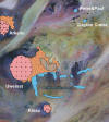
Distribution of Carboniferous layers
|
3.1 Carboniferous layer
Terrestrial paleovalley sediments
|

|

|

|

|

|
 |
|
Valley at NE-edge of
Uweinat: Warve-type sediment
|
Coarse grained
sandstone (with plant imprints)
|
Plant imprints (Loc
3)
|
Warve-type sediment |
River and coastal sediments
|

|

|
 |
 |

|
 |
|
Slab above Karkur Talh
|
Slab between
Karkur Murr and Karkur Talh
|
Slab above Karkur Talh:
Ripple marks |
Edge of eastern
Uweinat:
Downfall blocks with plants
|
|
Warve-type sediment
with ripple marks
|
|

|

|

|

|

|
|
|
fjexpedition 2017:
Carboniferous layers in the eastern foreland of Jebel Uweinat (Sudan)
|
|
3.2 Carboniferous plant imprints
Historic
finds
At Jebel Uweinat (Karkur Murr and Karkur Talh)
the Wadi Malik Formation contains
the following flora of Lower Carboniferous age:
Cyclostigma ungeri JONGMANS
Lepidodendropsis aff. rhombiformis DE ROUVRE
Lepidodendropsis cf. vandergrachti JONGMANS
Precyclostigma tadrartense LEJAL-NICOL
Directly east and southeast of Jebel
Uweinat as well as approximately 100 kilometers east of Jebel Kissu, both
in northwestern Sudan, the following flora was found:
Triphyllopteris cf. rhombifolia DABER.
Lepidodendron veltheimi STERNBERG
Lepidodendropsis vandergrachti JONGMANS
Prelepidodendron aff. lepidodendropsis LEJAL
Lepidosigillaria intermedia LEJAL
Archaeosigillaria vanuxemi KIDSTON
Precyclostigma sp.
Without exact statements to the
place of discovery in the Jebel Uweinat and surrounding are finds mentioned
of
Rhodea aff. lotzensis STOCKMANS
Cordaites cf. angulostriatus GRAND'EURY
Eskdalia africana LEJAL-NICOL
Eskdalia malikense LEJAL-NICOL
Eremopteris elegans E.L.
Ursodendron aegyptiacum LEJAL-NICOL
Archaeocalamites sp.
|

Eskdalia africana LEJAL-NICOL
|

Eskdalia malikense LEJAL-NICOL
|

Cyclostigma sp.
|

Precyclostigma tadrartense LEJAL-NICOL
|
|

Cyclostigma ungeri JONGMANS
|

Ursodendron aegyptiacum LEJAL-NICOL
|

Ursodendron aegyptiacum LEJAL-NICOL
|
|

Archaeocalamites sp.
|

Eremopteris elegans E.L.
|

Lepidodendron veltheimi STERNBERG
|
New finds
by travel participants
In recent years, and especially
in 2008, 2009 and 2013 by
Andras
Zboray, Hungary, and his groups,
were found new fossil plant-imprints on the northeastern part of the Uweinat
plateau. The plant-remains of the types "Lepidodendron", "Sigillaria", "Stigmaria"
and "Calamites"are usually not well preserved. The barely layered deposits
have a medium- or coarse-grained facies. It is likely that this deposits are
terrestrial, this means, products of the intra-erosion older deposits. This
facies differs from the coastal facies on the southeastern side of the Uweinat.
The plant-remains are preserved in situ. In contrast, the plant-remains in
shallow-marine deposits are allochthon of origin.
Now for the first time are corresponding plant imprints in the sediment by
Andras Zboray and group on the tour in 2013 at the eastern edge of the Jebel
Uweinat documented (see below).
|
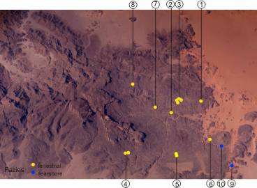
Locations (Loc
1 - 10)
|

Loc 1 -- Lepidodendron
sp.
|
|

Loc 2 -- Downfalled terrestrical
sandstone remains,
found on terrace 20 metres above valley floor
|
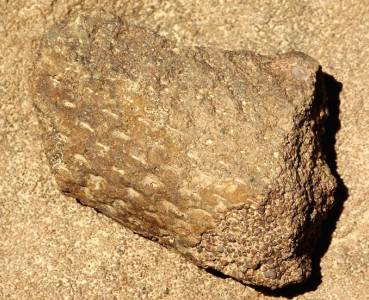
Loc 2 -- Stigmaria
imprint on coarse-grained sandstone
|
|

Loc ? -- Sigillaria
imprint
|

Loc ? -- Stigmaria
|
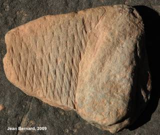
Loc ? -- Lepidodendron
aff. veltheimi
|
|
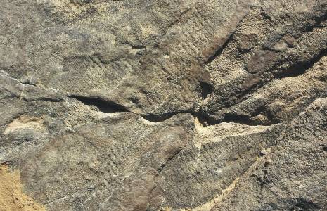
Loc 3 -- Roots
aff. Stigmaria
|
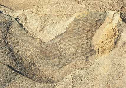
Loc 3 -- Sigillaria
|
|
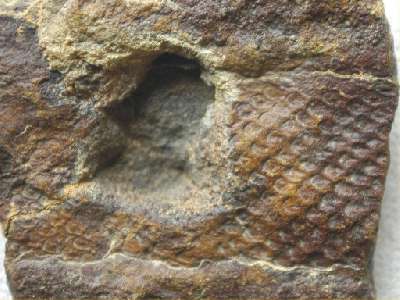
Loc 4 --
Lepidodendron aff. volkmannianum
|
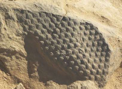
Loc 5 -- Sigillaria
imprint on fine-grained sandstone
|
|
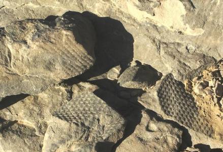
Loc 5 -- Sigillaria
imprints
|
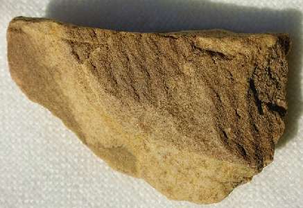
Loc 6 -- Lepidodendron
imprint
|
|
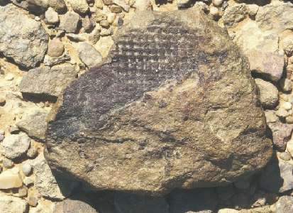
Loc 7 -- Sigillaria
aff. cancriformis
|

Loc 8 -- Sigillaria
aff. cancriformis
|
|
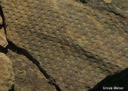
Loc
10 -- Ledidodendropsis
?
|
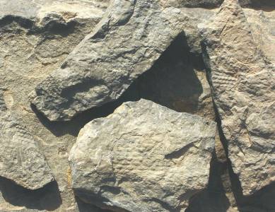
Loc 8 -- Sigillaria
imprints
|
|
New Loc 9 --
Large Lycophyta (Lepidodendron)
and Sphenophyta (Calamites) imprints
(Photos by Gabor Merkl & Andras Zboray)
|
C. Igneous and tectonic inventory
In the Jebel Uweinat
(Libyan part) we can see the unusual circular structure. These structure are
the surface expression of a granitic intrusion. This Granite intruded into
the Proterozoic metamorphic basement as well as Paleozoic sandstone strata
along a ring fracture. Three igneous activities has occured probably in the
Early Oligocene age (42-46 Ma).
The composite intrusion of the Jebel Uweinat is roughly circular with a diameter
of about 23 km, and is flanked on the northern side by three smaller overlapping
intrusive rings which are aligned along a north-northeast-trending axis. The
main complex is composed of deeply weathered alkaline rocks, forming very
large well-rounded blocks. The outer rim is formed by coarse-grained quartz
syenite which steeply slopes toward the surrounding basement. The rock is
assembled of quartz up to 12% and major euhedral perthitic alk-feldspar beside
minor aegirine. Toward the centre, in the south and west, the outer intrusive
ring is followed by a highly complex zone of coarse-grained quartz syenite
and coarse to fine-grained alkali granite. This zone forms the outer rim in
the north. According to KLERKX & RANDLE (1976), similar to the syenite the
alkali granite is essentially composed of subhedral alk-feldspar but with
an increased amount of interstitial quartz and aegirine. The central depression
of the ring complex is occupied by a reddish, fine-grained quartz syenite
with trachytic matrix that encloses rare phenocrysts of K-feldspar. The rock
is locally cut by trachytic dykes and sills. A steep inner slope around the
central quartz syenite depression is build up by alternating cone-sheets of
syenite, consisting largely of perthite with no quartz.
Outside of the granitic dome, on the remaining sandstone slab, are some interesting
igneous and tectonic implications to find.
Outside of the Granite dome
|

|
 |

|

|

|
 |
 |

|
|
Northern branch of
Karkur Talh: Basalt intrusions
|
Plug (Karkur
Talh)
|
Trachyte (Karkur Talh)
|
Sandstone columns
(Karkur
Talh) |
Igneous
structure
on
slab
|
Igneous penetration
on slab
|
|

|

|
 |

|

|
 |
 |

|
|
Large hills of
basalt intrusions (Andras Zboray, 2019)
|
Basalt
(between high plateaus)
|
Crater "White Spot"
with igneous basalt
(High plateau)
|
Quartz crystals
(Italia Plateau)
|
 |
 |
 |
 |
|
|
|
|
|
Trachyte outcrop in the upper part of Karkur
Murr (Andras Zboray, 2019) |
|
|
|
|
|
Lamprophyre dykes
(Lamprophyres are hypabyssal dyke rocks that have
mineralogical similarities to some Kimberlites and Lamproites)
|
|

|
 |
 |
 |
 |
 |
 |
 |
|
Karkur
Talh**
|
Karkur Talh (Andras
Zboray's "Blue vein")
|
Wadi Wahesh
|
Wadi Wahesh (Andras
Zboray)
|
 |
 |
|
|
|
|
|
|
|
On slab north of Karkur
Talh entrace (basalt ?)
|
|
|
|
|
|
|
**
A.A. Dadir, 1981 (Basement
rocks of the Gilf-Uweinat area) described in the Karkur Talh a Lamprohyre
dyke of 1m width and 400 m length in Paleozoic sandstone:
"An analyzed sample is a coarse-grained Spessartite, with angular texture,
and is mainly composed of augite and sanidine, with secondary minerals that
include carbonates, iron oxides, chlorites and zeolites. The Spessartite Lamprophyre,
characterized by its low SiO2 content, reflected in the absence of quartz."
|


